

X-Pyr 2026 Route Announced: A 528km Journey Through Seven Turnpoints Across the Pyrenees

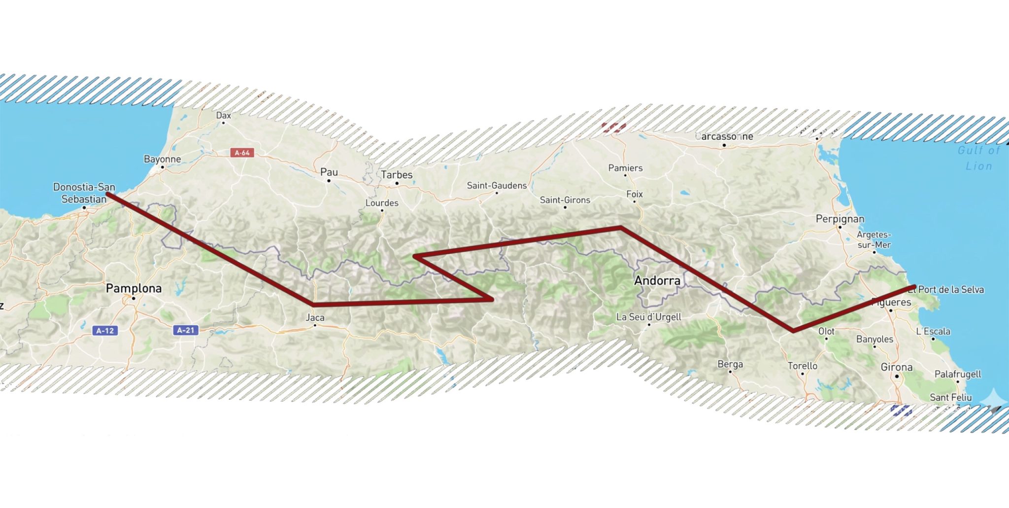
This year’s X-Pyr route has been unveiled — a demanding 528km course crossing seven turnpoints and touching both sides of the Pyrenees mountain range.
Organisers described the route: “The 528.8km course covers seven turnpoints before the final glide down to goal at El Port de la Selva. The race begins as always on the beach at Hondarribia. From there, competitors are required to run or hike to TP1 at Larun — they may not fly until they’ve signed the sign-in board. Only then can they proceed to the take-off area.”
From TP2 at Villanúa, athletes cross to the Spanish side and align themselves with the famed “Highway” thermal corridor along the southern flank of the range. TP2 is a sign-in point located in the village below. Before reaching TP3 at Aneto, racers must navigate some particularly tricky airspace — expect unusual dog-leg detours in the tracked routes.
Aneto, the highest summit in the Pyrenees, has featured as a turnpoint in previous editions. Its 3,000m exclusion zone offers pilots the choice of flying in or walking — depending entirely on the day’s conditions.
The X-Pyr 2026 route spans 528km across seven turnpoints
After TP3, the field turns northwest to cross the main ridge and clip the 13km radius around Pic du Midi de Bigorre. Though the distance between TP3 and TP4 looks short on paper, this leg covers some of the most remote and demanding terrain of the entire route, remaining above 3,000m for most of the way.
The most practical point to hit the Pic du Midi radius is the Arbizon peak near Saint-Lary-Soulan — a well-known flying site and a key passage for support crews transiting north-south across the Pyrenees.
TP5 at Pic des Trois Seigneurs marks a new addition to the X-Pyr route. With very few access roads between TP4 and TP5, this leg is expected to present a genuine logistical challenge for support teams.
After leaving this popular flying area, the route heads back south into Spain, threading between or around Andorra, before passing the famous Cerdanya hanging valley toward the next sign-in TP at Sant Joan de les Abadesses in Catalonia. From there, pilots have multiple options for reaching the final timed section at Santa Helena de Rodes.
Once past the last turnpoint, all that remains is the descent to the beach at El Port de la Selva — and the traditional celebratory swim in the Mediterranean.
A contingency Plan B route exists should weather deteriorate, and will be announced 24 hours in advance if required. This approach was used in the last edition to protect athlete safety.
The X-Pyr 2026 launches on 21 June 2026. For pilots tackling the Pyrenees with kit in tow, a purpose-built fast packing bag is essential gear.
Source: Cross Country Magazine